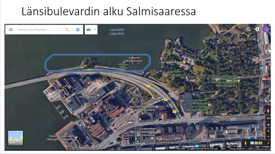
 I have to admit it: I miss urban planning. Maybe in spring 2017 I come back to urban planning department of the city of Espoo. In June, there are some decisions of the funding I have applied or where I would be employed if I continued my student leave with another 1,5 years. Anyway, Helsinki has its brand new master plan. It is innovative and up to date and even pioneering. The most important extensions of inner city are bulevardisations of the free ways. I Google Mapped the nearest Free way of my neighborhood. It is also the one that extends deepest into CBD of all the free ways. Now is the time to debate in which areas there should be master or detailed plans started. Länsiväylä would be ideal to start with. Drivers of the Länsiväylä suffers the least from the change because they have already drove the longest via the free way and accessed CBD much faster than from the other directions. In the surroundings of Länsiväylä there is plenty of potential for innovative growth and demand for professionals according to earlier studies (Inkinen & Kaakinen 2016, Kiuru & Inkinen 2017) In the blue area in the satellite picture could be mixed for example high rises of offices and apartments with sea views. Area would need just a little filling into sea. Some small islands and the banks of the free way are already existing potential construction areas. One of the advantages of the infill is, that the buildings would block the noise from the free way to important recreation areas like parks, jogging paths and sand beaches across the bay. It is also wise to develop areas that have been concluded as one of the most potential clusters to grow. Picture 2 shows the innovation potential of the Helsinki Metropolitan Area. Visualisation is poor just in case of southern Helsinki where symbols of potential should be more northern than in the picture. These areas include the bulevardisation of Länsiväylä. There is especially a huge potential of innovative growth and knowledge intensive establishments along the today free way. There is also demand of more apartments for professionals. All in all Länsiväylä would be great as one of the first inner city extensions of the new master plan. 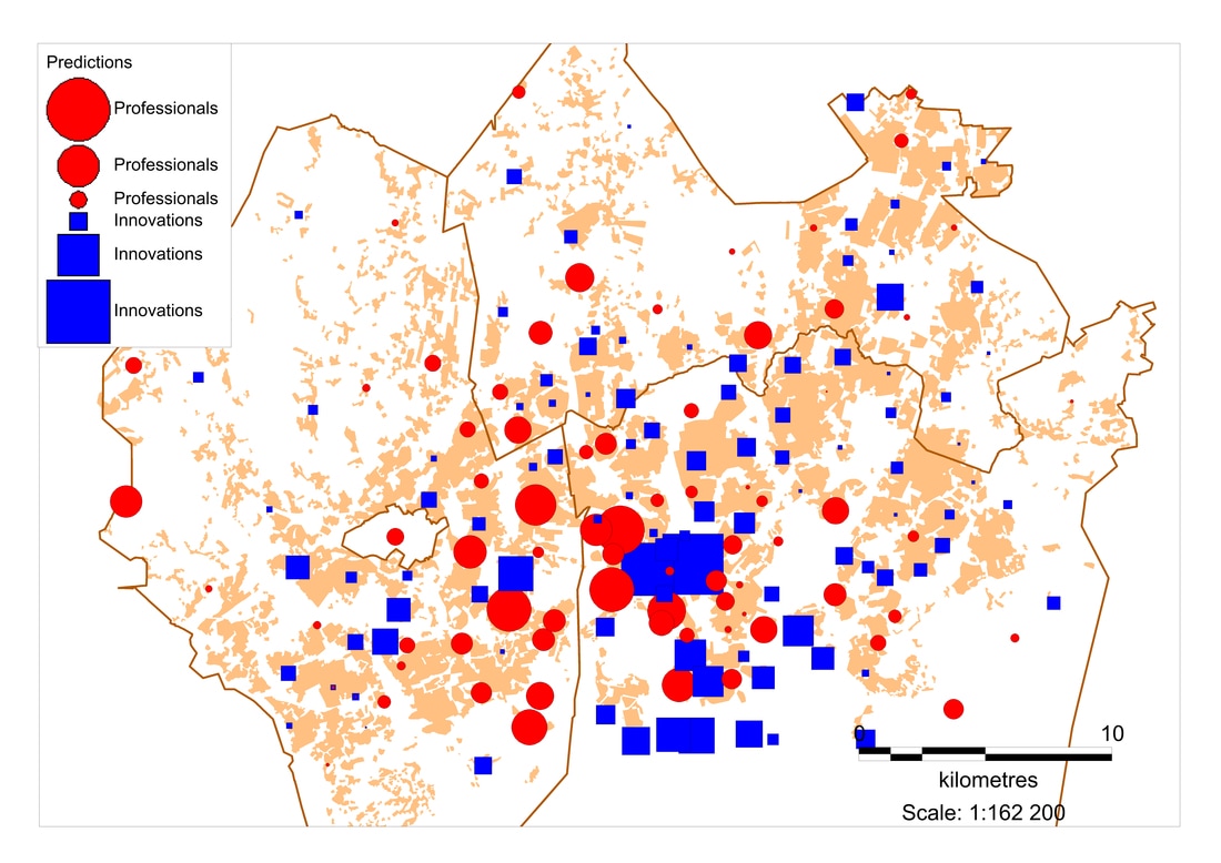
Comments
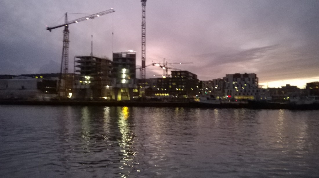 Below is the permanent link to recently published article in Cities journal. It is also the first article of my PhD thesis. Three more to go, I guess. Well, it's a start :) The picture above is from the construction phase of 18 store twin towers in Jätkäsaari, Helsinki, opened now as Clarion Hotel. Every tenth of the new high rises in Finland is built in Jätkäsaari district, an inner city extension of Helsinki. It has an enormous innovative potential, according to our study below:
http://dx.doi.org/10.1016/j.cities.2017.01.005 Kiuru, Juho & Inkinen, Tommi (2017). Predicting innovative growth and demand with proximate human capital: A case study of the Helsinki metropolitan area. Cities. Volume 64, April 2017, Pages 9–17. Juho Kiuru a, , , Tommi Inkinen b, a University of Helsinki, Department of Geosciences and Geography, Division of Urban Geography and Regional Studies, P.O. Box 64, (Gustaf Hällströmin katu 2a), FI-00014 University of Helsinki, Finland b University of Turku, Centre for Maritime Studies, Brahea-Centre, FI-20014 University of Turku, Finland  The first article of my PhD thesis was published in Cities journal. You can find it from this link for 50 days, until March 26, 2017.
Juho Kiuru a, Tommi Inkinen b, a University of Helsinki, Department of Geosciences and Geography, Division of Urban Geography and Regional Studies, P.O. Box 64, (Gustaf Hällströmin katu 2a), FI-00014 University of Helsinki, Finland b University of Turku, Centre for Maritime Studies, Brahea-Centre, FI-20014 University of Turku, Finland Highlights • Provides a postal code level visual analysis between human capital and innovation. • Provides a classification of high achieving and potential innovation areas. • Incorporates tolerance variable into empirical innovation studies. • Provides six regression models explaining the relationship between innovation and human capital. • Shows the significance of absolute variables in comparison to relative ones. Abstract Human capital is an essential driver for the growth of national and regional innovation systems. In this study, we can show that also intra-metropolitan innovation clusters locate in, or in proximity to, neighbourhoods with a high level of human capital. Our interpretation of human capital involves an educated, talented, creative and tolerant workforce. Indicators from earlier literature are complemented by identified new propositions. In addition, by using both relative and absolute measures, we conclude that innovations emerge the best in dense and mixed urban structure. After identifying the geography of human capital and innovativeness, we predict also potential growth areas, which could help urban planning of the HMA. The modelling methods used in this study can be implemented and applied in urban studies of other city regions. Keywords
Some previous innovation studies have recognized the existence of innovation paradoxes, meaning that some regions exhibit stronger (innovation prone) and some exhibit weaker (innovation averse) than expected economic growth relative to their R&D activity (Rodriguez-Pose 1999, Makkonen & Inkinen 2013). In my PhD thesis, I have identified the under- and overachieving clusters in Helsinki Metropolitan Area in regard to the present state geography of human capital. This gives major advice to planning authorities of the region by highlighting the areas with the most potential for innovative growth. Method is multivariate spatial regression with GeoDa software. Analyzing the connection between zip code area's and its neighbors level of human capital and cluster's innovative output, we get the predictions of the estimated innovative output of the cluster and the residual values of each area, which show how much the area's development is lagged at the present. Results show that new clusters of knowledge intensive jobs and thus innovations could emerge into outskirts of inner city of Helsinki as well as some sub centers in Espoo and Vantaa. Areas rasterized with both styles represent innovation prone areas in regard to both, absolute and relative level of nearby human capital. These areas are southern and northern edge of the inner city in Helsinki as well as Kera, Mankkaa and Laajalahti in Espoo and Jokiniemi in Vantaa. Findings encourage to sufficient zoning of commercial space in ongoing planning of inner city extensions in Helsinki and planning of certain new or developing sub centers in Espoo and Vantaa. 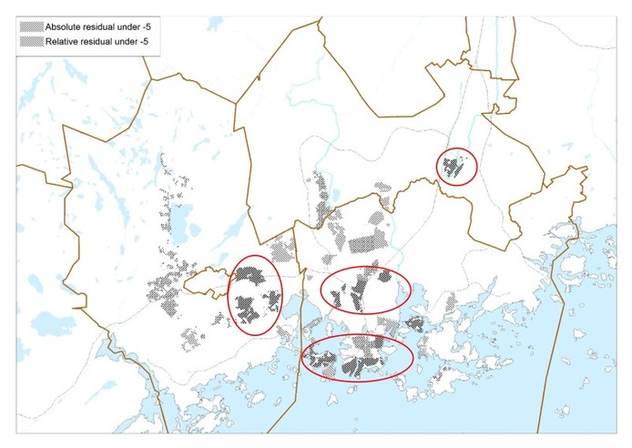 |
Photo by Rob Hurson
Categories
All
Archives
July 2018
AuthorJuho Kiuru, geographer living in Helsinki, Finland. |
 RSS Feed
